Authorized Sales Channel · Location & Master Plan
Etihad Town Phase 5 Map - Book Now, Get Master Plan First
See how the community is laid out — residential blocks, commercial zones, the road network, parks and the routes that connect it to Sharif Medical City Road and Raiwind Road.
Why Book With Us Before Master Plan Drops
The full block wise map – the one that shows exactly which plot you’re getting – doesn’t exist publicly yet. That’s normal at this stage. What matters is who finds out first when it does.
We're an authorized sales channel
When Etihad Group releases the official master plan, our booked clients hear it directly from us – not after it’s already circulating and the best blocks are gone.
We help you pick, not just notify you
When the plan lands, our team walks you through block positioning, corner options and pricing differences so you’re choosing with real guidance, not scrolling a PDF alone.
Booking your interest now costs you nothing and positions you for later
Register today – no obligation, just priority when it counts.
What the map shows
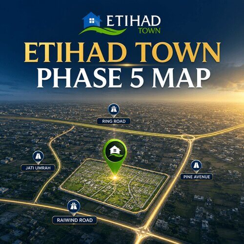
Etihad Town Phase 5 Map is designed as a well-organised, self-sustained layout. On the map you can trace the residential blocks, commercial zones, road network, parks and green belts, and the main access routes from Sharif Medical City Road.
- Updated block and map details
- Road connectivity
- Nearby landmarks
- Residential & commercial zones
- Access routes
- Future development insights
| What this map currently shows | Confirmed location reference - full block layout not yet published |
|---|---|
| Location | Sharif Medical City Road, southern Lahore - confirmed by our team |
| Full master plan | Released after official launch - book now to get it first |
| Get priority access | Register your interest |
Etihad Town Phase 5 Map
Indicative distances & drive times
Zoom, pan, and get directions to the Sharif Medical City Road location near Jati Umrah and the Sharif Medical Complex.
Master plan
Illustrative layout
Overview
A layout planned for flow and convenience
The design follows modern urban-planning principles, so that homes, shops, mosques, schools and green spaces sit in logical relationships rather than being scattered at random.
Wide boulevards and internal roads keep traffic moving, while commercial districts are placed where they serve the most residents. Parks and green belts are woven through the sectors to keep the environment open and healthy.
The map image shown here is illustrative. For the current, block-specific master-plan file with plot numbers, request it from the sales office.
Zones on the plan
What the Official Master Plan Will Include
Once released, a full Etihad Town master plan – the kind published for Phase 1, 2, 3 and, most recently, Phase 4 – typically shows:
Block Boundaries and Plot Numbering
so you know exactly which plot is yours
Commercial Zones
Dedicated areas for 4, 5.33 and 8 Marla commercial plots and plazas.
Road Hierarchy
From the main boulevard to internal streets
Parks & Green belts
Landscaped gardens, play areas and recreational open spaces.
None of this exists publicly for Phase 5 yet. It will, once the project officially launches – and when it does, the buyers who registered interest with us beforehand are the ones who get to choose from the full range of blocks before availability narrows.
Don’t wait until the map is public to start thinking about which block you want. Book your interest now and be ready to move the moment it’s released.
Getting to the site
Nearby Reference Points
For the full breakdown of landmarks, drive times and how this location connects to the rest of Lahore, see the complete location page. In short: near Jati Umrah and Adda Plot, close to the Sharif Medical Complex, with direct access to Raiwind Road.
From central Lahore
Take Multan Road, Lahore Ring Road or Ferozepur Road toward Raiwind Road, then follow Sharif Medical City Road.
Landmark to look for
The Sharif Medical Complex and Jati Umrah are your nearest reference points to Etihad Town Phase 5 Lahore.
Need a guide?
Our team can meet you on site – arrange a visit and we’ll share a live location pin.
Reserve Your Interest in Etihad Town Phase 5 - Be First When the Map Drops
- Priority notification the day the official master plan is released
- Direct guidance from our team on block selection, not just a PDF drop
- Combine with a payment plan reservation to be positioned on both fronts at once
- No obligation to book just by registering
FAQs
Frequently Asked Questions About Etihad Town Phase 5 Map
Is there an official Etihad Town Phase 5 master plan yet?
No – the project is in a pre-launch stage. Register your interest with us and you’ll be notified directly, with priority, the day it’s released.
What does this map currently show?
A confirmed location reference on Sharif Medical City Road – not yet a full block-by-block layout, since that’s tied to the official master plan. Contact our team for the exact site pin and a guided visit.
When will the block wise map be released?
Typically around or shortly after official launch, based on Etihad Group’s pattern with prior phases. No specific date is confirmed for Phase 5 yet – ask our team for the latest on timing.
How do I make sure I get a good block once the map is released?
Register your interest with us now. When the plan lands, our team walks you through block positioning and options directly – buyers who reserved early get first access before general availability opens up.
Can I get a copy of the master plan once it's released?
Yes – register here and you’ll be notified directly, with priority, along with the confirmed payment plan if you’d like both together.
Talk to Our Team
Get the confirmed location, register for priority access to the master plan, or book a site visit – all one conversation away.